The Mckenzie River Valley, located in the Central Oregon cascades, is a mecca for waterfall lovers. This stretch of river is home to half a dozen major waterfalls and dozens of other smaller waterfalls just waiting to be explored.
Proxy Falls is located a bit off the beaten path up the Mckenzie Pass Highway (HWY 242). This highway winds its way between Sisters, Oregon, and Blue River and is only open for a few months during the summer. The high elevation and extremely windy road make it too unsafe to drive in the winter so the Oregon highway department simply locks the gates on both ends in the late fall and reopens them in late June.
This means there is only a narrow window during the summer where you can drive up to the trailhead to access these Proxy falls. On the other hand, the locked gates mean that anyone who is willing to walk a couple of extra miles can most likely enjoy these falls all by themselves for the rest of the year.
This is exactly what we did!
Proxy Falls – What to Know
Proxy falls consist of two separate waterfalls known as upper and lower Proxy falls.
The falls are located on a loop trail that passes through conifer forests and old lava flows and is approximately 1 1/2 miles in length. This trail requires is generally easy but there are a few sections through the lava flow where footing can get a little tricky.
The short length and promise of visiting two waterfalls make this a perfect trip for families.
Note that the forest service recommends doing this loop in a counterclockwise direction.
Upper Proxy Falls

Upper Proxy Falls is the smaller of the two waterfalls. At 129 feet tall these falls gently cascade over and around moss-covered rocks and logs into a pool with, funnily enough, no output. The water drains into the lava rocks and disappears underground.
There is another small stream that cascades into the pool next to the waterfall and the whole scene makes for one of the most serene places in Oregon to sit and enjoy the sounds of nature.
Directly across from the falls is a steep wall intertwined with rocks and roots for the nearby fir trees. These roots have formed steps that make for a kind of natural amphitheater overlooking the falls and pool.
The small stream to the right of the falls flows through beds of moss so thick that it looks like a scene drawn for a Miyazaki film rather than real life.
To reach Upper Proxy falls head left on the trail from the parking lot. It is approximately .3 miles before you reach the sign pointing to the falls. The falls are another .1 miles along this trail. You can easily walk right up to the falls without any strenuous climbing downhill or over logs.
Yes, this is a hint of things to come!
Lower Proxy Falls
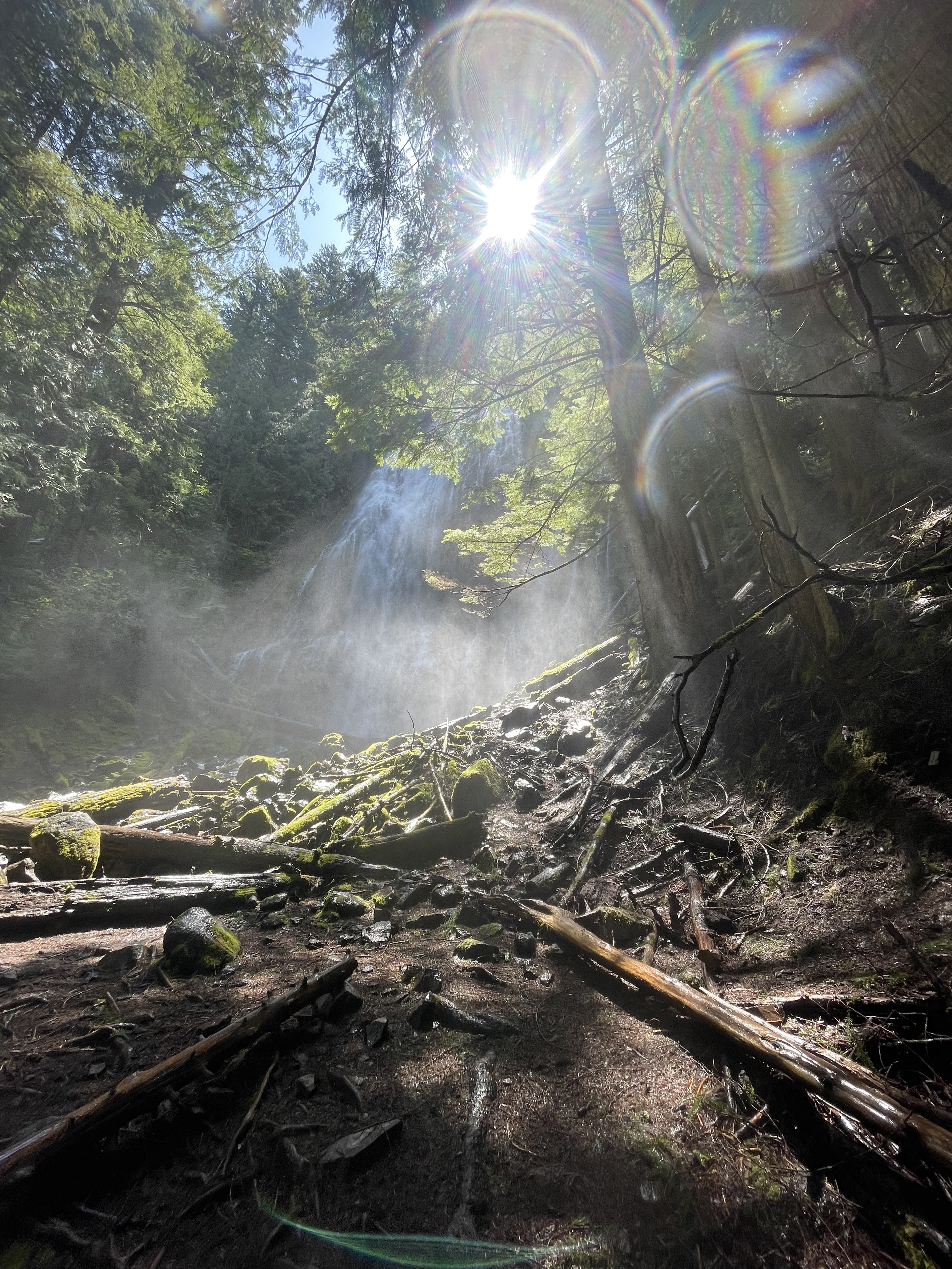
The bigger of the two falls, Lower Proxy Falls cascades 225 feet over the rock walls into the stream below. This dual-segmented waterfall has approximately twice the water flow of upper Proxy falls so be prepared for a shower if you choose to get close to the base of the falls.
The spur trail to Lower Proxy Falls is located approximately .7 miles from the trailhead when traveling in a counterclockwise direction. The spur offers a nice view of the falls through the trees from the top of the ridge. For those with a little more sense of adventure, you can make your way down the trail, climbing over or under multiple trees, to reach the creek.
From there it’s a choose-your-own adventure if you’d like to proceed closer to the falls. The creek here runs fast and cost so you’d be best served staying dry. There are numerous trees that can be used to cross the creek although these may pose a challenge in slippery conditions.
If you arrive in late morning the sun will be directly behind the falls which makes taking photos of the falls somewhat difficult. Your best bet is to climb up to the right side of the falls which both blocks the sun and gets you out of the ever-present mist. This is especially true during the late spring and early summer when the falls run fast.
Where are Proxy Falls Located?
The Proxy Falls trailhead is located near mile 65 of the Mckenzie Pass Highway and sits at an elevation of just over 3,000 ft. Getting here takes approximately 90 minutes from Bend or 3 1/2 hours from Portland.
This location is near the western end of the Mckenzie Pass highway approximately 2.5 miles above the western snow gate.
The trailhead only has a small number of parking spots right along the highway so if you’re planning on visiting on a busy summer weekend you may want to arrive earlier or later in the day.
Luckily, the loop trail to the falls is only 1 1/2 miles so cars should cycle in and out fairly frequently.
Tips for Making Your Trip to Proxy Falls a Successful One
- Check that the Mckenzie Pass highway is OPEN! The highway is typically open from late June through mid-November. If it is closed you can still park at the snow gate on the western end and hike in but this adds approximately 5 miles to your hike.
- Plan your trip for mid-week or visit early or late in the day. There is very limited parking at the trailhead so showing up at an off-peak time will help ensure you can find a spot to park.
- Know your limits on the trail. Scrambling up the falls requires walking across slippery logs and rocks. There is ZERO cell reception in this area so help may not be readily available.
- Visit the falls in late spring/early summer when the water flows are high or in the fall when the vine maples will be exploding with color.
- Pack a rain jacket or plan on getting wet if you want to get close to the lower falls. The spray is no joke!