Nestled in the foothills of the Central Oregon Cascades, Bend offers a diverse array of hiking trails and stunning scenery. From peaceful walks by the Deschutes River to challenging hikes in Smith Rock State Park to overnight summits of our resident volcanic peaks, there’s a trail for everyone.
These hikes will take you up and over volcanoes, across ancient (and not-so-ancient) lava flows, and through stands of towering pines.
We moved to this spectacular area for the outdoors and so far it has not disappointed! Now we’re excited to share our favorite trails near Bend with you!
Tips for Hiking Near Bend
Pack the Hiking Essentials: Extra layers, a first aid kit, plenty of water, and snacks. These are all items that may seem trivial, especially for shorter hikes, but our intense summer sun, quickly changing weather, and remote locations can turn an easy hike into an emergency in a heartbeat.
Pack Sunscreen: The summer sun in the high desert is no joke and many of the trails around Bend provide little protection. Once you get higher in altitude expect trees to be few and far between on many hikes.
Pack Extra Water: One thing that always throws us off when hiking in the high desert is how quickly our very cool mornings can turn into very hot afternoons. We’ve been on many hikes where the walk back to the car in the afternoon sun is way worse than any climbs we had to conquer during the early parts of the hike when the day was still cool. Pack plenty of water and consider keeping a water bottle with a built-in filter in your pack for quick fillups.
Prepare for Mosquitoes: Don’t skimp on the bug spray if you’ll be hiking during mosquito season. We keep a close eye on the trail reports before longer hikes as heading out during peak mosquito season without proper protection is a recipe for a bad bad time!
Bring Good Shoes: Many of the trails in this area are dominated by sand and jagged volcanic rock. This combination will at best get inside your shoes and at worst can lead to twisted ankles and skinned knees. Or worse! We usually hike in trail runners for day hikes or medium-weight hiking boots for overnight trips.
Plan Ahead: Check out the trail conditions on a site like Alltrails ahead of time. This is invaluable for knowing trail conditions, closures, bug situations, etc.
It’s also helpful to plan ahead for trails that require a permit. Many of the trails mentioned below require a Central Cascades Wilderness Permit and these permits do sell out. Sometimes within minutes of becoming available.
We highly recommend reading through the permit site to familiarize yourself with when the permits are made available and which trailheads they are required at as this information does change year-to-year.
Don’t Forget the Parking Pass: Almost all of the trailheads mentioned below require a NW Forest Pass ($30 annually) or $5 day pass. If you’ll be spending any amount of time on the trails in the Pacific Northwest then the annual pass is a worthy investment. Especially since many trailheads don’t have an option for purchasing a day pass on-site.
The Best Hikes Near Bend
Todd Lake to No Name Lake
- Length: 13.7 Miles
- Difficulty: Difficult
- Elevation: 2,200 ft
- Hiking Permit Required: Yes
- Parking Permit: NW Forest Pass
This was my most recent big hike in Bend and I have to say it may just be my favorite yet.
Maybe it’s because I hike 7 miles in near-total darkness only to arrive at my destination within 30 seconds of the sun rising over the horizon. Hustling for 2 hours by headlamp made watching the sun light up the basalt cliffs feel all the more magical.
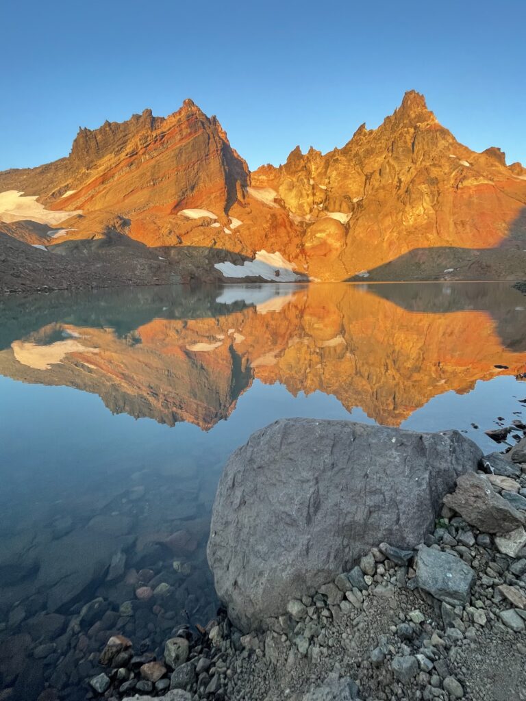
Or maybe it’s just the fact that No Name Lake, which sits at the base of the peaks of Broken Top, is one of the most beautiful places in all of Oregon.
There are quicker ways to get to this lake as you could start from either Crater Ditch or Broken Top trailheads. The downside of these shorter hikes is driving the EXTREMELY rugged roads that lead to these trailheads.
Seriously this road could easily pass as the worst in all of Oregon. Despite that, there is, without fail, one car a year that makes it up that defies all odds. Just don’t be that person who doesn’t make it up…
I like starting from Todd Lake for the challenge of a longer hike and to just spend more time outside on our amazing trails around Bend.
The hike itself is fairly mellow. There is 2,200 feet of elevation gain but it is very gradual for 98% of the hike. The only steep sections come in the last mile and they are fairly short.
I’d recommend bringing a map or using a mapping app like Alltrails or Gaia as there are a few (signed) intersections to navigate and some climbing trails that are easy to wander down.
Tip: All three of the trailheads (Todd Lake, Crater Ditch, and Broken Top) that lead to No Name Lake require a Central Cascades Wilderness Permit. As do a number of the hikes we’ll mention below. These permits are available on a rolling basis that tends to get adjusted a little each year so keep your eye on the permit website for details.
Canyon Creek Meadows Loop
- Length: 7.4 Miles
- Difficulty: Moderate
- Elevation: 1,600 ft
- Hiking Permit Required: Yes
- Parking Permit: NW Forest Pass
The Canyon Creek Meadows hike (it can be done in a loop or out and back) is an annual tradition for our family. Once wildflower season hits we make sure to snag a permit and head up for one of the best wildflower shows in all of Central Oregon.
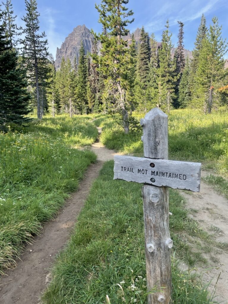
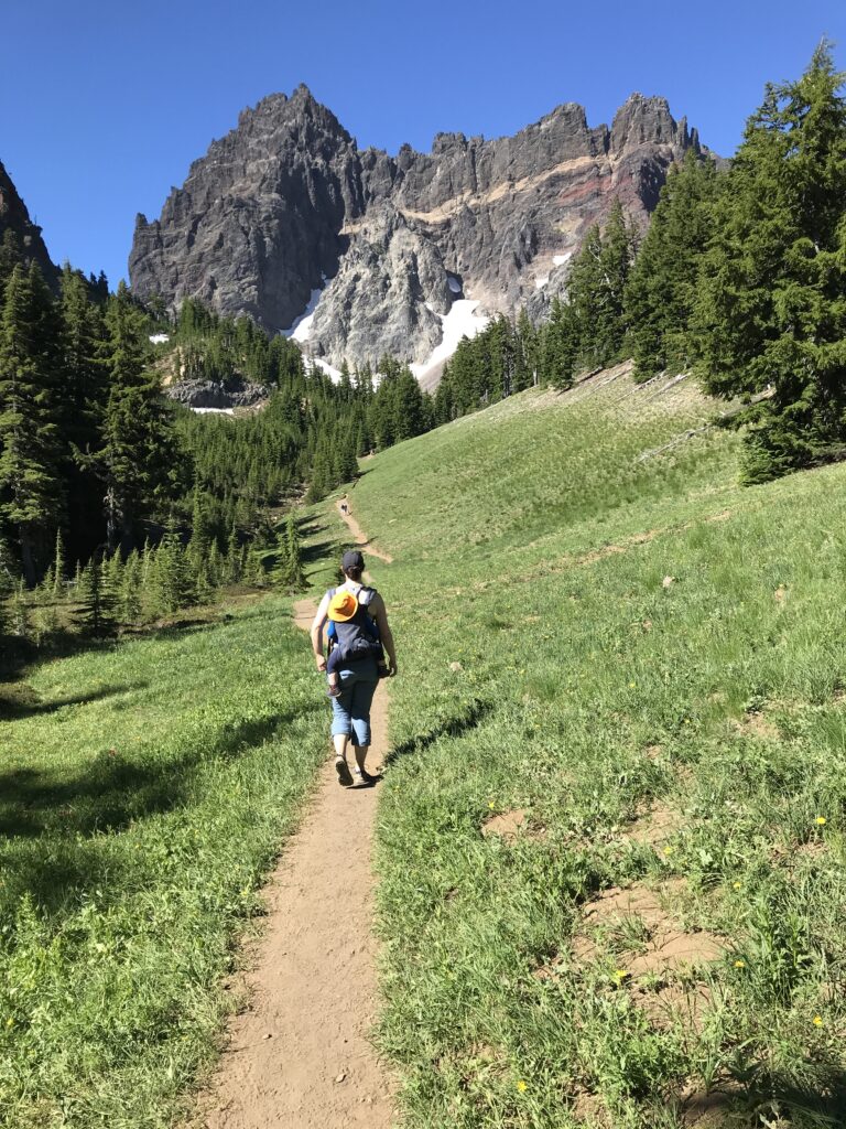
This hike is located approximately an hour north of Bend near the base of Three Finger Jack. This mountain, like Broken Top, is made of heavily eroded basalt which turns a brilliant orange when lit up by the morning sun.
The hike itself meanders through 3 different alpine environments during the short 3 miles to the base of Three Finger Jack.
The first part of the hike starts out in the remnants of a 20-year-old forest fire with ghost trees still dominating the landscape.
After a mile, you’ll make your way into a lush forest that, unfortunately, is a mosquito haven during the earlier parts of the hiking season.
The last mile is the real treat though!
Here you break out into wildflower-filled meadows that are perfectly framed by mountain cliffs. Look for lupine, fireweed, beargrass, shooting stars, and indian paintbrush along the trail.
After the meadows you’ll pass through one last section of trail before heading uphill to the saddle of the mountain.
This last push is up a steep scree field and we have never gone all the way up as we always bring the kids and they’d much prefer to play in the mountain streams rather than fill their shoes with rocks for one last view.
The views from the top are supposed to be stunning though with unobstructed looks over the entire cascade range.
If you take the loop trail on the way back you’ll catch a glimpse of a small waterfall. There are also some nice beargrass blooms but we typically just do the hike as an out-and-back.
Tip: Keep your eyes peeled on the cliffs of Three Finger Jack and you may catch a glimpse of the mountain goats that call this area home.
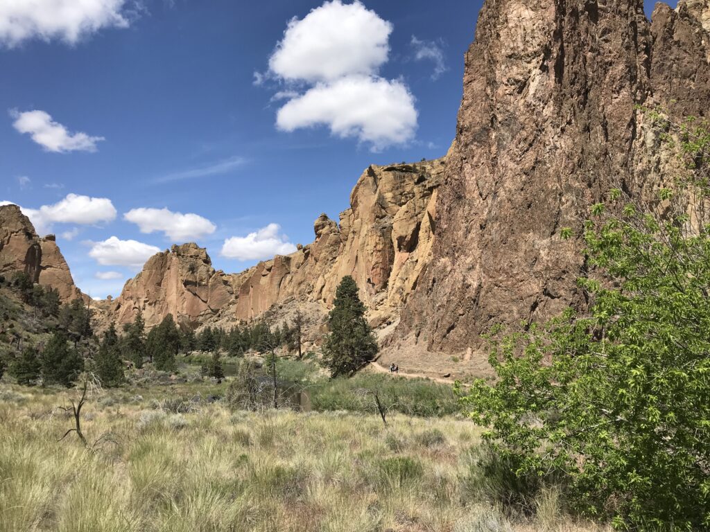
Misery Ridge Trail at Smith Rock
- Length: 3.6 Miles
- Difficulty: Difficult
- Elevation: 900 ft
- Hiking Permit Required: No
- Parking Permit: Oregon State Parks Pass
The Misery Ridge Trail at Smith Rock State Park is one of those absolute must-do hikes for every outdoorsy adventurer in Bend. While the trail itself is short (other loops can be done to make it a much longer and more challenging outing) don’t think that you won’t break a sweat when ascending up the Misery Ridge Trail.
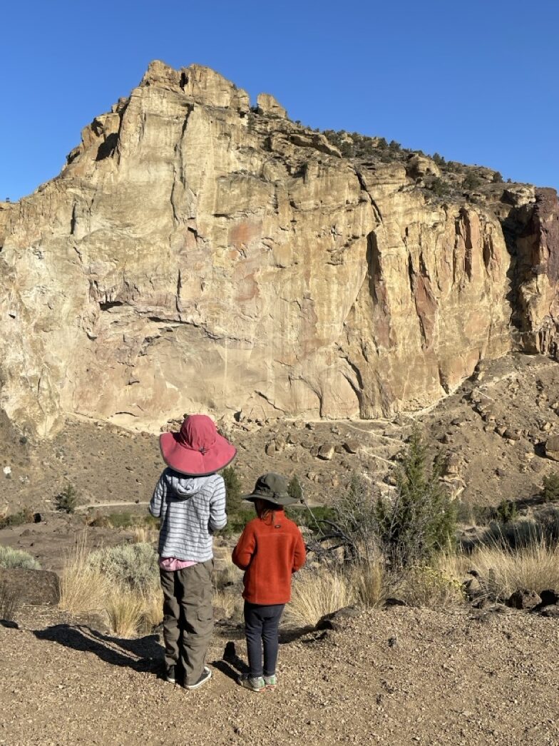
Take a look at the photo above for a glimpse at the switchbacks that you’ll be starting out with on this hike! And yep, your ultimate destination is on top of the backside of that cliff.
The pain of climbing and the risk of a rattlesnake encounter (seriously there are a ton of snakes here) is well worth it once you see the view from the top of this amazing Central Oregon hike.
Once you arrive at the top you have a few options to get back to your car.
You can head back along the river trail to make for a mellow loop back to the start or you can head north along the summit trail which will add 3 miles and 800 feet of climbing. This longer route provides for some incredible views of the entire park so it is well worth it!
Alternatively, you can head back the way you came although sometimes it can be just as hard going down as it was coming up when the trail is this steep.
Tip: If you’re doing this hike in the summer make sure to leave early in the morning and bring more water than you think you’ll need as this park gets blazingly hot in the afternoon.
Tam McArthur Rim Trail
- Length: 5.3 Miles
- Difficulty: Moderate
- Elevation: 1,200 ft
- Hiking Permit Required: Yes
- Parking Permit: NW Forest Pass
The Tam McArthur Rim Trail is one of the most popular trails for accessing Broken Top and the Three Sisters Wilderness from the North end.
This trail climbs up through stubby forests to a cliff face that can be seen from downtown Bend. From here you have up-close views of Broken Top and the rest of the Cascade range.
While the Rim itself is the ultimate destination for most embarking on this hike you can also continue on to No Name Lake and beyond.
The trail starts and ends right next to Three Creek Lake which makes for a nice cooldown after a hot summer hike!
Tip: The upper portions of this trail offer minimal shade so start early to avoid the hot summer sun. This is a recurring theme for many hikes near Bend!
Mckenzie River Trail
- Length: 2 – 20 Miles
- Difficulty: Easy
- Elevation: Minimal
- Hiking Permit Required: No
- Parking Permit: No
The McKenzie River is a spring-fed river that winds its way through the Deschutes National Forest north of Bend. This area is known as one of the best fly fishing rivers in all of North America as it is home to huge bull trout that require a high level of fishing mastery to catch.
It also attracts anglers, hikers, mushroom foragers, and campers alike for its stunning beauty as the crystal clear waters of the Mckenzie flow through this nearly untouched wilderness.

This area is one of our favorites to camp and hike as the campgrounds along the river are generally small and quiet, and have the McKenzie River Trail running right through them.
That means we can wake up, cook some breakfast, and wander up or down the trail as far as we want on any given day.
Take the trail south and you’ll wind through campgrounds, past fly fishermen, by a fish hatchery, and eventually find your way into the quaint town of Camp Sherman.
But if you head north you’ll quickly find yourself in a more canyon-like setting where it’s just you and other adventurous hikers and bikers.
South Sister Summit from Devils Lake
- Length: 11.6 Miles
- Difficulty: Very Difficult
- Elevation: 5,000 ft
- Hiking Permit Required: Yes
- Parking Permit: NW Forest Pass
Summiting South Sister is probably THE number one goal for hikers in Bend. This 10,363-foot-tall mountain dominates the skyline in Bend and entices hearty adventurers who are looking for the ultimate challenge without having to move on to true mountaineering.
The hike up to South Sister starts at Devils Lake along the Cascade Lakes Highway. In years past, prior to the Central Cascades Wilderness Permit requirements, the parking lots and roadsides would fill up with cars by 5am on many summer mornings.
Nowadays it’s a bit easier to find parking but I still wouldn’t expect much solitude on this very popular trail.
The hike itself is pretty straightforward and almost feels like you’re just out on a walk for the first few miles as the trail is very wide and well-maintained.
Once you hit the real climb though you’re in for a treat!
From here it is 3,000 feet up a not always well defined trail. Expect to do some scrambling over rocks and walking uphill through the equivalent of moon dust and rocks that WILL make their way into your shoes.
I didn’t wear gaiters on my last hike up and was very much regretting it when I was emptying out my shoes for the 10th time.
Take your time to explore once you get to the top as there are a ton of cool views from all sides of the crater.
Tumalo Mountain Trail
- Length: 4.1 Miles
- Difficulty: Difficult
- Elevation: 1,400 ft
- Hiking Permit Required: No
- Parking Permit: NW Forest Pass
Missed out on a Central Cascades Wilderness Permit? Only have a couple of hours to kill and want to get in a leg burner of a hike with some A+ views?
Well, then Tumalo Mountain is the hike for you!
The trailhead for Tumalo Mountain is only 30 minutes from downtown Bend and the hike itself is short enough that you can knock everything else, including the drive up and back, in under 3 hours.
4 hours if you include the post-hike beers at a local brewery.
The hike up Tumalo Mountain offers up iconic views of Mt. Bachelor. This is a nice distraction as the trail starts going uphill the second you leave the parking lot and doesn’t stop until you reach the top!
The trail is never terribly steep though so while it is a workout it is also a very hikeable/runable/skiable/snowshoeable trail.
Green Lakes Trail
- Length: 9.1 Miles
- Difficulty: Difficult
- Elevation: 1,200 ft
- Hiking Permit Required: Yes
- Parking Permit: NW Forest Pass
The popularity of the Green Lakes area may be the number one reason why the Central Cascades Wilderness Permit system was put in place.
Love it or hate it: this area had become an absolute zoo and the solitude you can now find up there is a welcome change.
Once you make it up to the Green Lakes area you’ll quickly understand why this is such a popular spot. With the trailhead being so close to Bend (< 35-minute drive) and so much access to incredible hiking and camping spots it’s no surprise that this area was loved to death.
This out-and-back trail near Bend takes you through alpine forests, by waterfalls, and up to the perfect lake for a summer dip.
There are A TON of trails that crisscross this area making it easy to put together multi-day backpacking trips or epicly long day hikes without ever being too far from civilization.
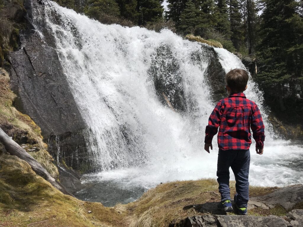
Tumalo Falls Trail
- Length: .5 Miles to 7 Miles
- Difficulty: Easy/Moderate
- Elevation: Varies
- Hiking Permit Required: No
- Parking Permit: NW Forest Pass
Some locals may scoff when you mention hiking to Tumalo Falls. During the summer it’s nothing more than a 30-second walk from your car to the lookout point.
Even a hike to the top of the falls, while uphill, doesn’t take more than 15 minutes.
Those folks are missing out on everything that the Tumalo Falls Trail truly offers.
The trail will take you well beyond Tumalo Falls up into the high country where you’ll pass by numerous other waterfalls and most likely enjoy some well-deserved solitude (minus the occasional mountain biker.)
This is one of our favorite trails near Bend to take the kids as it is close to town and we can hike as much or as little as we want knowing that there is a waterfall to excite them at the beginning AND end of the hike!
Sparks Lake (Ray Atkeson Trail)
- Length: 2.5 Miles
- Difficulty: Easy
- Elevation: Minimal
- Hiking Permit Required: No
- Parking Permit: NW Forest Pass
The Ray Atkeson Trail, or Sparks Lake Trail, is one of the most interesting trails in the region (and we have plenty of them!)
The trail follows the shore of Sparks Lake and will take you past some very interesting lava flow features like hidden tunnels and deep cracks that run right next to the trail.
Sparks Lake is also an attraction all to itself with some of the best views of Mt. Bachelor and its varying seasonal water levels as it fills with snowmelt in the spring and slowly drains out by the end of summer.
Bring a paddleboard to enjoy this stunning area by water after getting your hiking fix!